


Frederick Law Olmsted, the father of landscape architecture, once called Boston’s Emerald Necklace “the most important work of our profession now in hand.” His elegant system of parks tamed the Muddy River, diverting flood waters and sewage, while lacing together diverse neighborhoods from the Back Bay to Franklin Park.
While it’s impossible to imagine the Boston of today without Olmsted’s gem-like system of connected parks, some of his visions weren’t realized.
Olmsted once planned to connect Franklin Park to the waterfront via Columbia Road, for example. The proposed boulevard would have linked the Emerald Necklace with Pleasure Bay in South Boston, but it was never built. Where Olmsted envisioned a lush parkway traveling through Roxbury and Dorchester, today’s Columbia Road is a gritty streetscape of snarled traffic and sparse foliage. See what it looks like today in the video below:
Zoom in on the map below to see Olmsted’s plan for Boston’s Emerald Necklace. Green areas denote Olmsted’s ribbon of parkland running through Boston; portions that were never built appear in red.
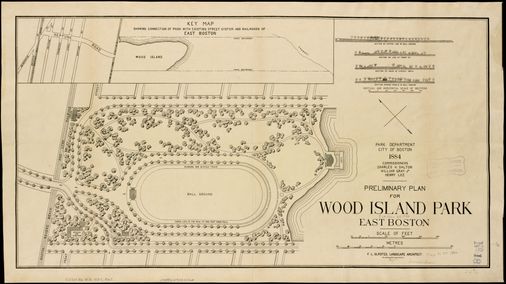
And while Olmsted designed other parks around Greater Boston, not all of them survived. East Boston’s Wood Island Park, which Olmsted began designing in the 1880s, was later razed — its greenery sacrificed to make room for Logan International Airport in the 1960s.

The plan below shows a simple park featuring a few walkways and a playing field, but the 46-acre park ultimately offered picnic areas, a public beach, tennis courts, outdoor gymnasiums, playgrounds, and several promenades. Despite Wood Island Park’s popularity, the park was demolished for the expansion of the airport, setting off decades of community activism and park advocacy.


Brittany Bowker can be reached at brittany.bowker@globe.com. Follow her on Twitter @brittbowker and on Instagram @brittbowker.
Read More: Maps: What Boston could have looked like if Olmsted’s original plans were


