


The National Hurricane Center could release tropical storm watches and warnings later today for Florida residents as the disturbance off the Yucatan Peninsula is expected to develop.
Putting hurricane models at odds with one another, the disturbance, which is the remnants of the Pacific Ocean’s Hurricane Agatha, has an 80% chance of reforming into a tropical depression or storm in the next two to five days but its future destination remains uncertain, the NHC said in its 8 a.m. update. If the storm reforms with at least 39 mph winds, it will become Tropical Storm Alex and become the first named system of the Atlantic season.
[ MAP: Here’s the latest forecast track of potential tropical system threatening Florida ]
On Monday, Agatha — the first storm of the Pacific hurricane season, which started May 15 — took form as Category 2 hurricane and made landfall in Puerto Angel, Mexico. The storm dissipated Tuesday over the rough Mexican terrain, but not before killing at least 10 people with another 20 missing, according to the governor of the southern state of Oaxaca.
:quality(70)/cloudfront-us-east-1.images.arcpublishing.com/tronc/RCHKEUCLX5DUTGR342RGAWUL5U.png)
The NHC believes it will likely reform by the weekend.
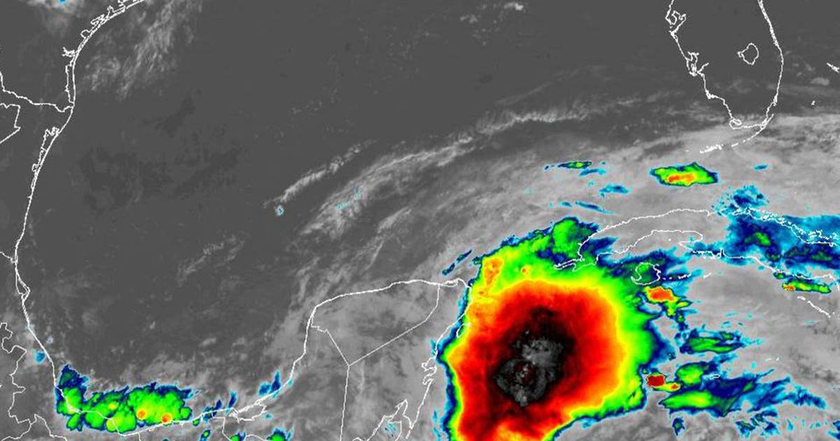
The disturbed area of storms is near the Yucatan Peninsula and in the Southeastern Gulf of Mexico. Forward motion of the system slowed Thursday morning, but NHC hurricane specialists are warning Floridians to keep their guard up as the Sunshine State remains an area of interest for the system’s future.
As to exactly what will become of Central Florida, models are in disagreement with each other.
“It’s the difference between two main models,” said Spectrum News 13 meteorologist Bryan Karrick.
The European storm model shows the slower movement of the Gulf disturbance bringing heavy rain to Florida on Saturday and cooler temperatures, Karrick said. However, the American GFS model shows the system moving much faster with less rain Saturday and much hotter temperatures.
Meteorologists are expecting to have a better idea of where the disturbance is likely to travel after observing it more in the Gulf and seeing a few more storm model runs.
On Monday, Hurricane Agatha made history as the strongest hurricane ever recorded to come ashore in May during the eastern Pacific hurricane season, ripping off roofs and washing out roads before fading Tuesday in southern Mexico.
Oaxaca state Gov. Alejandro Murat told MVS Noticias on Tuesday that eight people were listed as missing in either mudslides or flooding.
The storm hit Oaxaca state Monday afternoon as a strong Category 2 hurricane with maximum sustained winds of 105 mph, then quickly lost power as it moved inland over the mountainous interior.
Meanwhile, the surface trough 200 miles northeast of the central Bahamas has diminished, the NHC said in its 8 a.m. update.
Last week, the National Oceanic and Atmospheric Administration released its hurricane season predictions, stating a 65% chance of experiencing an above-average 2022 Atlantic hurricane season, beginning June 1 and running until Nov. 30.
Orlando Sentinel staff writers Lisa Maria Garza, Richard Tribou and The Associated Press contributed to this report.
More Hurricane Coverage:
Read More: Tropical watches, warnings could come for Florida today, hurricane center says – Orlando Sentinel


