


The National Hurricane Center has issued a hurricane watch for Florida’s east coast from the Brevard-Volusia county line south to Hallandale Beach as Subtropical Storm Nicole formed Monday morning in the Atlantic Ocean with a projected path predicted to bring it toward the state by Wednesday night as hurricane.
Gov. Ron DeSantis has also issued a State of Emergency for 34 counties in the potential path of the storm including all of Central Florida.
“While this storm does not, at this time, appear that it will become much stronger, I urge all Floridians to be prepared and to listen to announcements from local emergency management officials,” DeSantis said in a press release. “We will continue to monitor the trajectory and strength of this storm as it moves toward Florida.”
Counties in the order are Brevard, Broward, Charlotte, Citrus, Clay, Collier, DeSoto, Duval, Flagler, Glades, Hardee, Hendry, Highlands, Hillsborough, Indian River, Lake, Lee, Manatee, Martin, Miami-Dade, Nassau, Okeechobee, Orange, Osceola, Palm Beach, Pasco, Polk, Putnam, Sarasota, Seminole, St. Johns, St. Lucie, Sumter and Volusia.
As of 1 p.m. EST (2 p.m. AST), the system was located about 465 miles east of the northwestern Bahamas and about 690 miles east of Cape Canaveral with maximum sustained winds of 45 mph moving northwest at 9 mph. It’s expected to slow down its forward speed later Monday and begin a west to west-southwest push from Tuesday to Thursday.
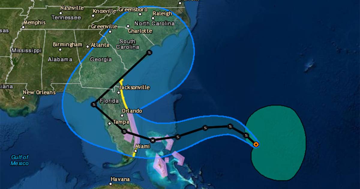
“On the forecast track, the center of Nicole will approach the northwestern Bahamas on Tuesday and Tuesday night, move near or over those islands on Wednesday, and approach the east coast of Florida Wednesday night,” said the NHC advisory.
:quality(70)/cloudfront-us-east-1.images.arcpublishing.com/tronc/SXLKULYN6ZC7HCMDGTCCGRYIEM.png)
The hurricane watch also was issued for Lake Okeechobee inland with a tropical storm watch from the Brevard-Volusia county line north to Altamaha Sound, Georgia. A storm surge watch is also in effect for Altamaha Sound, Georgia south to Hallandale Beach, Florida. The government of the Bahamas has also placed the northwestern Bahamas under a hurricane watch.
The National Weather Service in Melbourne also placed inland Brevard County under a hurricane watch with inland Lake, Orange, Osceola, Seminole and Volusia counties under a tropical storm watch.
While classified now as subtropical with a massive wind field with 40 mph winds out as far as 275 miles, the forecast predicts it will transition to a tropical system with a more defined eye with higher wind speeds around the eye at the center of its circulation.
[ MAP: Here’s the latest forecast track for Subtropical Storm Nicole ]
The latest advisory predicts it will become a hurricane while over the Bahamas on Wednesday night on its way to Florida with 75 mph winds and gusts up to 90 mph.
“Regardless on the ultimate intensity of Nicole, the storm’s large size due to an enhanced pressure gradient north of the storm will likely cause significant wind, storm surge, and rainfall impacts over a large portion of the northwestern Bahamas, Florida and the southeastern coast of the United States during much of the upcoming week.
The five-day forecast shows a path that could have it making landfall somewhere between Miami and Brevard County, and then traveling northwest across the state south of Orlando and out into the Gulf of Mexico north of Tampa Bay on Thursday, then shifting Friday and getting pulled back to the northeast up into the southern U.S.
The NHC defines a subtropical cyclone as similar to a tropical system, meaning a low-pressure system with a closed surface wind circulation about a well-defined center with some deep convection. But its winds will be spread out much farther with less symmetry than the dense centers of a tropical storm, and will have cooler upper-level temperatures in its core. Tropical systems gain much of their energy from warm waters that…
Read More: Subtropical Storm Nicole prompts Florida hurricane watch


