


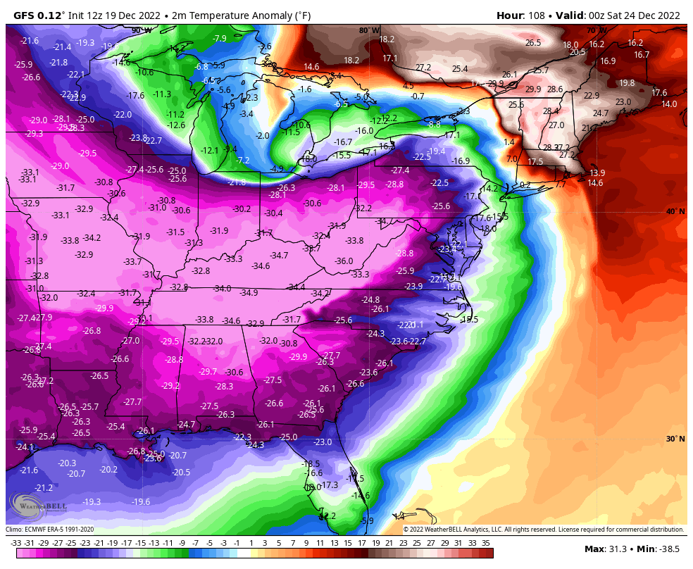
The D.C. area will see its most significant effects from this extreme weather pattern after the cold front passes on the back end of the Great Lakes storm Friday. Temperatures will plummet below freezing and winds will roar, and we can’t rule out some snow showers or flurries. Washingtonians will experience the coldest air of the season so far.
A little wintry mix possible early Thursday
We could see a little wintry precipitation in the region just as the storm system moves into the area Thursday, provided it’s early enough in the day. Even if that happens, any sleet, snow or freezing rain would probably be brief and focused west of the Interstate 95 corridor.
With temperatures mainly above freezing as precipitation arrives, the winter weather potential from this system on the front end seems even less threatening than last Friday’s storm, which mainly produced rain in the area (aside from some freezing rain far west and northwest).
The milder temperatures are mainly the result of high pressure sliding off the northeast coast before the storm arrives, which helps set up a warmer wind flow off the ocean. The storm center is also expected to be more powerful compared with last week’s, which should help deliver plentiful and relatively warm south winds ahead of the Arctic front that won’t arrive until late Friday.
The Baltimore/Washington Weather Service office has western counties of our area under a slight risk of wintry weather Thursday and Friday, but no risk in the immediate area. Anything in the way of significantly disruptive wintry weather should be confined to mountainous areas to our west.
After picking up around 2 inches of rain late last week, another inch or two of rain seems ready to visit late this week.
The heaviest rainfall is most probable between late Thursday and Friday morning. There could even be a rumble of thunder Thursday night or Friday given the warmth and moisture surging north ahead of Friday’s cold front.
Here’s what some recent model runs are showing for precipitation, both in D.C. and the range for the local area in parenthesis.
- European ECMWF — 0.9 inches (0.75-1.5 inches)
- American GFS — 0.9 inches (0.75 to 1.5 inches)
- Canadian GEM — 1.2 inches (1 to 1.5 inches)
Washington has seen 2.41 inches of rain in December compared to 3.41 inches as an average for the entire month. The next storm should push the city near and above normal for precipitation this December.
How much temperatures will drop and when
Friday is setting up to be a wild day for temperatures locally. Readings soaring into the mid-50s to around 60 seem a good bet east of the Blue Ridge in the morning, as the storm center swirls through the Great Lakes and a strong cold front approaches the region.
Current weather modeling suggests the front passes Washington in the midday, and temperatures immediately plummet rapidly in its wake. Numbers could fall off to and below freezing in western parts of the area during the afternoon, then in D.C. and east by sundown or so.
As cold air rushes into the area, it will quickly cool enough for any precipitation left behind the front to become snow. There probably won’t be much falling at this point, but some flurries, snow showers or a brief snow squall could blow by. Under the right conditions, a coating or so could fall in spots.
By Friday night, the region is looking at wind chills as least as cold as…
Read More: Major storm to soak D.C. area before a frigid Christmas weekend


