


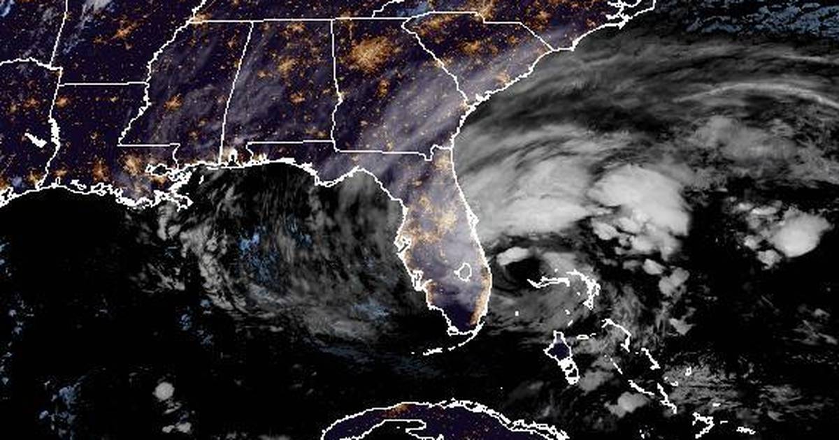
Hurricane Nicole has made landfall on the east coast of the Florida peninsula on North Hutchinson Island just south of Vero Beach in Indian River County with maximum sustained winds of 75 mph (120 km/h), according to the National Hurricane Center.
In a special update at 3 a.m. Thursday, the NHC said Hurricane Nicole was located about 15 miles north-northwest of Fort Pierce and heading west-northwest at 14 mph. A hurricane warning remains in effect from Boca Raton to the Volusia-Flagler county line.
An earlier update from the hurricane center noted that Nicole’s large eye, over 57 miles in diameter, was bringing a large swath of “tropical-storm-force winds over its northern semicircle,” with “large intense bands extending quite far from the center.”
The NHC reported that hurricane-force winds currently extend outward up to 25 miles from the center and tropical-storm-force winds extend outward up to 485 miles, especially to the north of the center.
An NOAA buoy located about 25 miles east of Cape Canaveral reported a sustained wind of 56 mph and a wind gust of 67 mph at 2 a.m.
An NOAA tide gauge at Fernandina Beach in Nassau County also observed a water level of 4.5 feet above Mean Higher High Water – the average height of the highest tide recorded each day around 2 a.m. Fernandina Beach is located near Jacksonville on Amelia Island and is Florida’s northernmost city on the Atlantic coast.
Spectrum Bay News 9 in Tampa reported wave heights of up to 22 feet in St. Lucie, 19 feet in Volusia and 18 feet in Brevard counties on the Atlantic coast of Florida. Meanwhile, wave heights also began to grow on Florida’s Gulf coast, with waves up to 11 feet in Pinellas and 10 feet in Manatee counties around Tampa Bay.
Earlier, the NHC reported that a weather station at Sebastian Inlet recently reported a sustained wind of 48 mph with a wind gust of 66 mph, while another station near Stuart Beach reported a sustained wind of 47 mph with a wind gust of 62 mph. Patrick Space Force Base had a peak wind gust of 62 mph around 11 p.m.
“Hurricane conditions are expected across portions of the coast of southeast and east-central Florida tonight, where a Hurricane Warning is in effect,” the NHC said. “Tropical storm conditions will continue along the east coast of Florida, Georgia, and South Carolina within the warning areas into Thursday. Tropical storm conditions are expected to begin along the west coast of Florida tonight and Thursday.”
:quality(70)/cloudfront-us-east-1.images.arcpublishing.com/tronc/D33ZY7L7PVBKVEI3PMAGQMSSSY.png)
Thousands of Floridians are under evacuation orders in advance of Nicole.
Already storm surge is breaching sea walls and slamming up against beachside structures along the entire Florida east coast left vulnerable from Hurricane Ian. Rain squalls and high tide led to flooded streets in South Florida up into the Treasure Coast as outer bands from the massive system ventured inland during the day. Ahead of its arrival Disney and Universal announced shutdowns while several Florida airports halted operations.
Several structures were deemed unsafe in Daytona Beach Shores prompting police to evacuate them as waves caused more erosion, according to a report from NBC affiliate WESH while social media posts from and ABC affiliate WFTV reporter Christy Turner showed structures “falling into the ocean” as the waves continued their surge.
The NHC said the system made landfall on Great Abaco Island, Bahamas at 11:55 a.m.
:quality(70)/cloudfront-us-east-1.images.arcpublishing.com/tronc/HS7ONITZL5G77ITFFGXS32ZDAE.PNG)
It’s a…
Read More: Hurricane Nicole made landfall south of Vero Beach


