


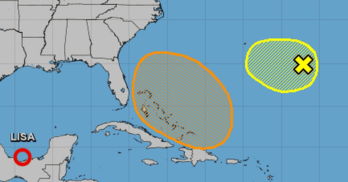
The National Hurricane Center forecast an increased chance that a tropical depression or storm could form in the Atlantic and potentially threaten Florida in the next five days.
As of the NHC’s 8 a.m. tropical outlook, forecasters predict a large nontropical low pressure system will develop this weekend over the northeastern Caribbean Sea and southwestern Atlantic near Puerto Rico.
“The system is initially expected be very broad and disorganized, but it could begin to acquire subtropical or tropical characteristics by the end of the weekend,” forecasters said. “Environmental conditions could support additional gradual development early next week and a subtropical or tropical depression could form while the disturbance moves generally northwestward or westward over the southwestern Atlantic.”
Chances for formation were increased to 40% on Friday for it to form in the next five days.
Space Launch Delta 45′s Weather Squadron Launch Officer Mark Burger on Thursday said he was also keeping an eye on the system as a potential threat to NASA’s Artemis I mission and the $4.1 billion worth of hardware that is at Kennedy Space Center’s Launch Pad 39-B waiting for a mid-November launch attempt.
“There’s still a lot of inconsistencies on exactly where that may end up and really whether or not it even does acquire any significant tropical characteristics to even become a named storm. That’s all very much out in play at this point,” he said. “However, that being said, the models are very consistent on developing some sort of a low pressure and regardless of whether or not it’s named, pretty much what we’re targeting, is that for the middle part of next week, especially as we go Monday night, potentially Tuesday night, early Wednesday, us having the highest impacts from that particular system as it approaches the Florida peninsula.”
He said it looks like at worst it could bring sustained winds of 25-30 mph with gusts approaching 45 mph.
“Those were well within our constraints of riding out, so we’ll have impacts from that in terms of the wind, but again, we’re not looking at any likelihood at this point of being a strong system emerge out of this,” he said. “However, again, we are continuing to watch that for potential impact in the middle of next week.”
If it grows in strength, it could become Tropical Storm Nicole.
The NHC is also continuing to issue advisories on Tropical Depression Lisa now in the Gulf of Mexico while also monitoring a weak nontropical area of low pressure located several hundred miles east-southeast of Bermuda with only a 10% chance to form in the next couple of days into a named system in the Atlantic.
:quality(70)/cloudfront-us-east-1.images.arcpublishing.com/tronc/NDLF6EW3RNGMDDBUCPO3MQNRXE.png)
As of 11 a.m., TD Lisa was located about 185 miles west of Ciudad del Carmen, Mexico in the Bay of Campeche with maximum sustained winds of 35 mph moving northwest at 7 mph.
“A gradual turn toward the north at a slower forward speed is expected by Saturday morning. Lisa or its remnants are then forecast to stall and move very little through the remainder of the weekend,” forecasters said. “Slight strengthening is possible today. Lisa is forecast to begin weakening by Saturday morning and will likely become a post-tropical remnant low by Saturday night.”
The week has seen the formation of the season’s sixth and seventh hurricanes with Hurricane Lisa striking Belize on Thursday morning and Hurricane Martin, which became extratropical in the north Atlantic by Thursday afternoon.
The Atlantic hurricane season runs through Nov. 30. The season’s 14 named systems through Martin have now met the NOAA forecast for 2022.
The NOAA has predicted to be an above average season with 14 to 21 named tropical storms. This follows 2020′s record 30 named systems and 2021′s 21 named storms.
Read More: Hurricane center ups odds for system to form near Florida – Orlando Sentinel


